Point Ritchie-Moyjil has fascinated scientists for decades.
The geology of the headland reveals a past that includes changing sea levels, volcanic and seismic activity.
Geologists are working with the indigenous community and archaeologists to help tell the story of Point Ritchie-Moyjil.
In March 2019 research into the origins of marine shells and what could be an ancient hearth at Point Ritchie-Moyjil was published by the Royal Society of Victoria.
The research, produced after several years of study and analysis by scientists from a range of disciplines, can be viewed at the CSIRO publications website.
Archaeology
Monash University Professor of Indigenous Archaeology Ian McNiven first worked with indigenous communities of the South West in the 1990s in a previous role with the Victorian Native Title Office.
He says the archaeology of the region is “extraordinary” but says further research is required to be certain about evidence which suggests human occupation at 60,000 to 80,000 years ago.
“What you have at Point Ritchie tells a story that goes back certainly 200,000 years and particularly in the last 100,000 years there are all sorts of preserved fossil deposits there that let us know about the sea coming and going, rising and falling.
“With that is the Aboriginal history which we know for sure goes back at least 6,000 years. You can see the evidence in terms of shells and campsites, charcoal from fires eroding out of the dunes and they have been firmly radio-carbon dated to the last 6,000 years.
“The story gets interesting because it could be much older and when I say much older at least 10,000 and maybe 20, 30, 40, 50,000 - we’re not too sure yet.
“The evidence we have for early material; one, there’s charcoal features, the question is: are they fireplaces or are they just burnt-out stumps? It seems like an easy thing to distinguish … but unless you’ve got stone tools or food remains associated with the charcoal … then it’s very tricky.
“In terms of the shells, the shells are fascinating, certainly when you have an initial look at they do appear to be similar to what Aboriginal shell middens look like. There’s a narrow range of shells take from the adjacent reef flats, the turbo shells … a lot of them are smashed which you also get in many midden deposits. People would smash them open in a very particular way to extract the meat. The trouble is we also know there are a number of natural processes that create the same sort of deposit. The two most obvious ones are storm surge and tsunami deposits. The other one and the really tricky one is that certain types of birds break the shells and they will pick them up from a height then smash them on the rocks and they have a particular spot where they do the smashing.
“Are the shell deposits human, are they bird deposits or is it a tsunami or a storm? We’re pretty sure it’s not a storm surge deposit or tsunami because there would be other sediments there that would let us know that. Is it a bird deposit or a human deposit? The more research we do on bird deposits the more it’s starting to look like that … but again, it’s early days and we still have to work through the evidence, do the measurements etc, but it’s tantalising.”
- Ian McNiven
Geology
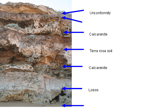
Rock layers at Point Ritchie-Moyjil show the influence of very different climate conditions over the past 300,000 years. Sea level has risen and fallen – at its highest reaching present levels about 125,000 and 220, 000 years ago. During these times of higher sea level and milder climate (called Interglacial Periods) dunes formed on ancient coasts just as they do today (we are living in an Interglacial Period). Over time the sand grains were cemented together and the loose sand became a rock called calcarenite. The large hill to your right is a sand dune formed 125,000 years ago. The rock stack at the sea’s edge opposite the lookout behind you is the remains of an older dune – formed over 200,000 years ago. Remains of a beach from 125,000 years ago are also preserved at Pt Ritchie. Sea level then was about 3-5m higher than now.
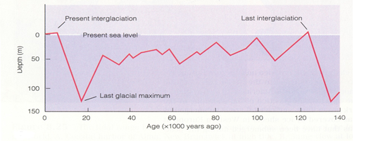
Between these Interglacial Periods the Earth was colder and sea level fell. The fall in sea level is caused by ice build-up on the continents – leaving less water in the oceans. These cold times are called Glacial Periods or Ice Ages. Dune building ceased here at these times and terra rosa (“red earth”) soils developed on the now stable dune surface. Natural cement layers, called calcrete formed at the base of the soils because of the dry conditions. One rock layer at Pt Ritchie consists of a one metre thick dust storm deposit (loess) reflecting these arid times.
Also preserved here is evidence of ancient earthquakes and a volcanic ash mantle, a legacy of the Tower Hill eruption 35,000 years ago. Tower Hill is one of the largest maars in the world and was formed when groundwater came into contact with hot rising basaltic magma. Tower Hill is included in the Kanawinka Geopark, a region of south-west Victoria and south-west South Australia that encompasses the the Newer Volcanic Province of Southeastern Australia.
It is hard for us to imagine the violent events that have shaken this headland in the past. Moyjil has evidence that it was occupied by Aboriginal people during these dramatic natural events.
Volcanic Activity
Dozens of extinct and dormant volcanoes mark the landscape of south-west Victoria and south-east South Australia. They are contained within the 15,000sqkm region known as the Newer Volcanic Province of South-eastern Australia
The youngest of the volcanoes is Mount Shank near Mt Gambier in South Australia which is thought to have erupted about 5000 years ago.
Tower Hill, a crater formed about 35,000 years ago, is important in the story of Point Ritchie-Moyjil. Ash from the Tower Hill explosion formed a layer across the landscape including at Point Ritchie. It has become a key marker of time, informing us that the evidence thought to indicate human activity occurred before the Tower Hill eruption.
Tower Hill, with its crater lake and cinder cone islands, is contained within a State reserve covering more than 600ha.
More information on Tower Hill and the volcanoes of the South West can be found at www.kanawinkageopark.org.au